Fine Art Photographs
National parks preserve cherished life experiences - stories handed down from generation to generation, or handed over from loved ones and friends. To fully experience Acadia, leave your car at least a hundred yards behind. Then inhale the fragrance of isolation, which will sharpen your senses to the sounds, sights and aroma of this magic place. The scent of balsam perfumes the air in the forest, and the salt air merges to deliver the sea to you. Here is the natural world as we rarely experience it anymore, soul-satisfying and memorable.
As artist Wayne Hill spotted this sailboat as it passed near Isle au Haut, Maine, and followed it until it moved into a composition that worked. The sun did the rest! He has the large-format photograph, but wishes that he had the sail as well! Image # 01764.
The tides in Maine are significant. At Acadia's Sand Beach, as the tide recedes it leaves behind abstract art, momentarily visited by water. This just makes you want to stop and admire - or please walk around these patterns. Image # 01796.
The rocks and profile of Otter Cliffs have become an icon for Acadia National Park and for Maine in general. Located along the "loop road" within Acadia, it is heavily courted by artists and tourists. Be there at dawn and it is all yours. Image # 01799.
Near the center of Mount Desert Island, Maine, lies this delightful pond in Acadia National Park. At one end are the twin sensual peaks called The Bubbles, while at the other sits the Jordan Pond House, known for its memorable popovers. John Rockefeller built carriage trails around this pond, which today are great for hiking and biking. Did Artist Wayne Hill mention those hot popovers fifty yards away? I wonder where he went... Image # 01809.
Artist Wayne Hill knows why this lighthouse is among the most photogenic in Maine. With the rugged coast often shrouded in fog, it offers historic navigational aid to passing sailboats. Located outside Bass Harbor and within Acadia National Park, it is heavily courted by artists and tourists, as well as nostalgic windjammers cruising offshore. Image # 01905.
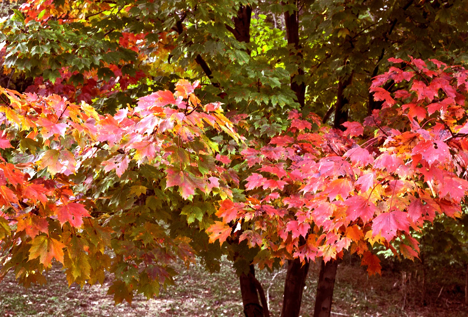
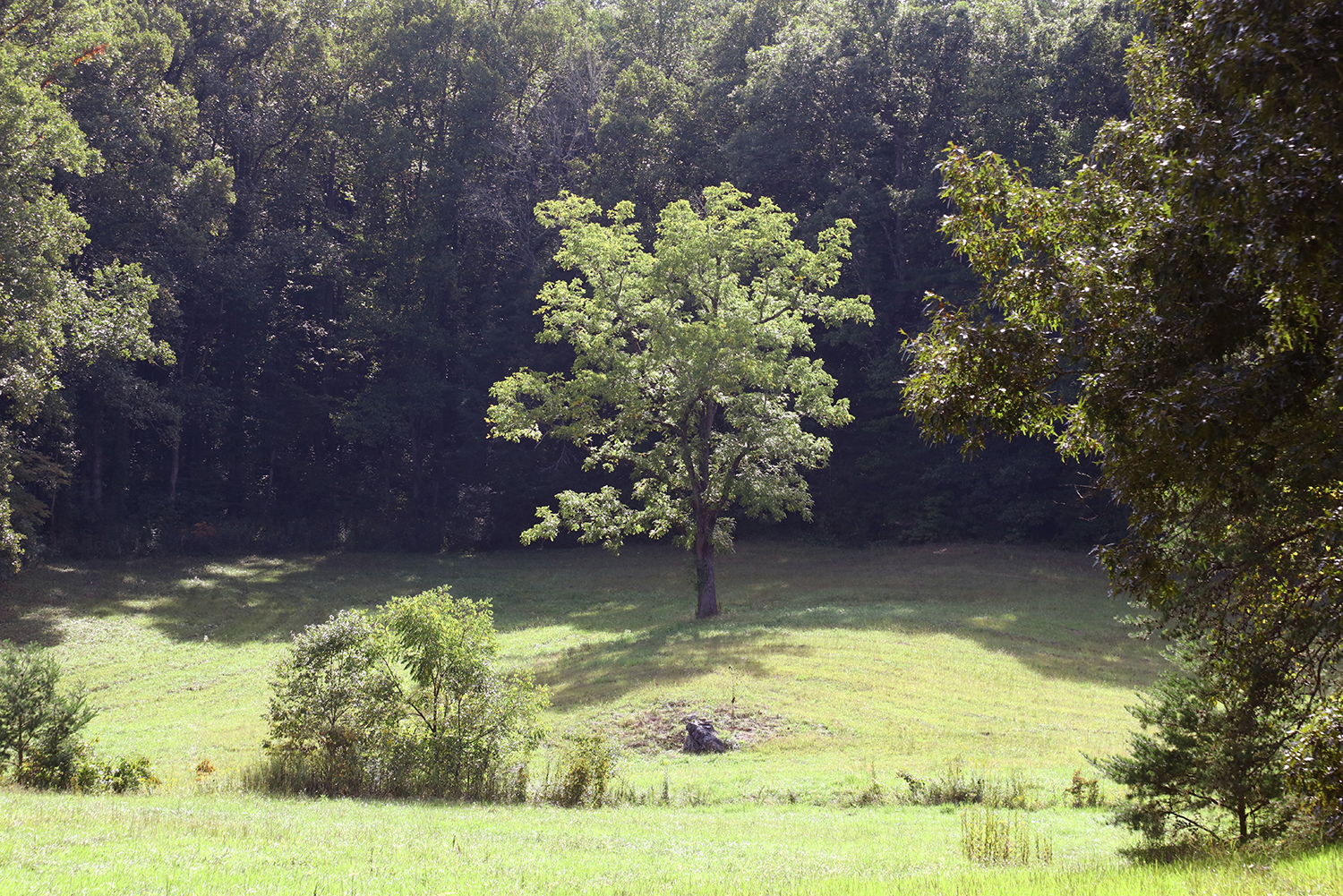
Maples in New England wait all year to perform in October. This tree called to artist Wayne Hill as he was looking for art in Acadia National Park, Maine. Image # 05521.
The ferns near the carriage trails in Acadia National Park are gentle in summer and become spectacular in October. Image # 35024.
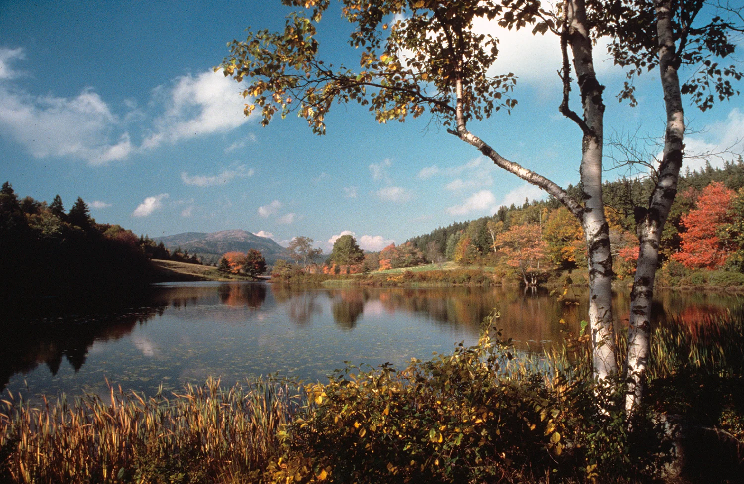
This pond is one of artist Wayne Hill's long time favorites. On the edge of Acadia National Park, it sits back from Seal Harbor, Maine, bordering the former Rockefeller mansion (that had 44 bedrooms and 22 bathrooms). A great place to sit and meditate. Image # 36301.
This delightful view of Western Mountain is located on Mount Desert Island, Maine, between Southwest Harbor and Seal Cove. Wayne Hill spent his childhood summers on this island, and passed this scene on his way to Carroll's Drug Store soda fountain for a mandatory chocolate ice cream soda. Ayuh! This scene can mark the highlight of another perfect day in Maine. Image # 36442.
The strong colors of these birches and maples are powerful in the morning sun along the trail leading to Otter Cliffs. Image # 36898.
Many of the trees in Acadia are pines, much more important than lowly sumac - until October when the sumac colors turn red and orange. Take an early morning hike along the Otter Cliffs trail and imprint this view. It will soon pass. Image # 36990.
Photographs of light houses often look great in sunshine - yet they were created to guide ships in weather conditions of poor or no visibility. Image # 37057.
The crisp air of Acadia in October transforms simple leaves into elegant colored formations. Add a bit of dew at dawn, and we have a striking photograph! Image # 38111.
At low tide, it is possible to walk to the east side of this iconic light - just be very careful on the slippery rocks, and do not stay too long as the tide may be coming in. Image # 39071.
The foliage near Acadia's Sieur de Monts Spring is wonderful in early October. You can even smell the aroma of fall colors. Image # 39072.
You have to leave Mount Desert Island in order to see the profile of Acadia National Park. This view from across Frenchman's Bay is impressive, calling you to soon return. Image # 39073.
The pond at Seal Harbor is on the edge of Acadia, and usually is calm - wish you had your canoe handy? Image # 39074.
Most of the land that we enjoy as Acadia National Park was donated by John D. Rockefeller, Jr. - along with 45 miles of "carriage roads" so he could enjoy touring the interior of Mount Desert Island without competing with automobiles. Here is one of the two gate lodges he built at entry points to the roads; this one is near the Jordan Pond House in Northeast Harbor. Image # 39082.
This is a fine contrast in textures - between the gentle fern fronds and the peeling bark of the birch. Acadia is splendid from a distance and indeed from up close as well. Image # 39084.
I thought about walking across the stones to get closer to The Bubbles, but realized how chilly the water is in early March. What was worse, the Jordan Pond House was not open yet, so my dream of having warm popovers - remained just that. Image # 08355.
Late September brings a palette of brilliant colors. This early performance was on the shore of the Hudson River. Image # 05491.
Blue Mountain Lake lies in the southwestern area of the vast Adirondacks State Park in New York. Artist Wayne Hill paddled his canoe to this island in the pre-dawn fog to be ready when the sun burned through. Image # 05492.
This complex waterfall is located at the end of a hike in New York's Adirondack State Park. This picturesque waterway meanders through thick forest and rugged terrain. Yet artist Wayne Hill could not get Frank Lloyd Wright's magnificent Pennsylvania home out of his mind. Listen - do you hear it? Image # 05496.
This tiny island sits in Blue Mountain Lake in the southwestern region of New York's huge Adirondack State Park. Artist Wayne Hill had seen it the day before and returned by canoe in dense fog, before the sun burned through to awaken Blue Mountain Lake. Image # 05611.
Near the banks of the Hudson River in the southern Adirondack State Park in New York, the maples and birches compete for attention. Artist Wayne Hill will take them both, especially at the peak of fall foliage. Image # 05647.
Along the shores of Upper Saranac Lake, in the Adirondack State Park near Lake Placid, several of the remaining Great Camps maintain an important presence. This one features an amazing deck, just inviting you to unplug and linger. Time is one of life's most precious commodities - spend it wisely. Image # 06836.
Along the shores of New York's Elk Lake, near North Hudson, a 12,000-acre private forest preserve is nestled in the heart of the High Peaks. This was described by the National Geographic as "the jewel of the Adirondacks". Enjoy the solitude of this tranquil wilderness resort. Image # 06837.
Artist Wayne Hill found these white Adirondack chairs calling him on a warm October afternoon in Adirondack State Park, NY. After he made this panoramic photograph, he yielded to temptation and relaxed a while on the shore of Blue Mountain Lake. Second chair from the left. Image # 05480.
Artist Wayne Hill loves the sweet light of dawn, and waded out into the shallow waters of Lake Saranac to compose this panorama. One of the many visual treats in Adirondack State Park, NY. Image # 05485.
As the leaves descend in late September in New York's Adirondack State Park, the air has the fragrance of fall. This stream sounds larger than it really is, and feeds into Lower Saranac Lake. Image # 05486.
The pristine sand dunes near Stovepipe Wells are constantly reshaped by the wind, and reach heights of 120 feet. These substantial sand dunes are more impressive against the backdrop of the Amargosa Range, located near the center of Death Valley National Park. Image # 07265.
The large sand dunes at Mesquite Flat silently sweep across a surreal-looking landscape. As you approach these magnificent dunes, you wonder "where did they come from?" There are theories but no answer to the question. One way to give scale to these dunes: it would take a good hiker at least 90 minutes to go from the artist's tripod to the top peak. Image # 07266.
There is a geologic counterpoint to the undulating Mesquite Dunes and the harsh 5,000' Amargosa Mountains close by. The Wind shapes and re-shapes the land continuously. Image # 07267.
This view of Manly Beacon at Zabriskie Point demonstrates the varied landscape of Death Valley National Park, from mile-high peaks to below sea-level valleys. This point delivers an extraordinary panoramic view of the Panamint Range on the west side of the giant Salt Playa. Image # 07268.
Looking down from Zabriskie Point in the soft pre-dawn light, these foothills display remarkably diverse coloring. These colors come alive when direct sunlight hits them. Image # 07271.
No, this is not Neapolitan ice cream. Varied mineral deposits, left by volcanic activity near these ancient black mountains, create a spattering of colored rocks along the drive near Artist's Point in Death Valley National Park. Image # 07272.
The Funeral Mountains in Death Valley National Park earned their name by being part of a harsh environment to early visitors. Many who wanted to pass through this valley during their search for gold in California did not survive. Despite this information, the appearance of this lunar topography is extremely attractive to a geologist. Image # 07274.
These bone-dry multi-colored rock formations rise above Badwater Basin in Death Valley National Park. The high salt content on the valley floor makes plant life impossible, and gives the area an unearthly landscape. These richly tinted hills change color as the light travels across the sky. Image # 07275.
Death Valley's moving rocks in the Racetrack Playa create questions. How did they get there, how do they move? These rocks weigh up to 700 pounds yet mysteriously travel extended lengths of the desert without anything to move them but the wind. Image # 07277.
Death Valley's moving rocks are indeed mysterious. A research project suggested that a rare combination of rain and wine enable the rocks to move as far as 1,500 feet. Rain of 1/2" will wet the mud surface of the playa, providing a firm but extremely slippery surface. Strong winds in excess of 90 mph are common in Death Valley, and may skid the large boulders across the slick mud. Image # 07278.
Death Valley National Park is the hottest, driest and lowest spot in North America. This image was made in a difficult-to-reach remote area of the large park. The mystery surrounding these sliding rocks made the rugged 4-wheel drive journey worthwhile. Image # 07279.
The "Racetrack" in the northwestern corner of Death Valley features large rocks that appear to have skated across the mud flats, when the high wind and rare rain-covered mud allowed for it. A unique phenomenon in nature! Mirages are common on this surface and on the giant Salt Playa as well. Image 07280.
You gotta love the will to live in these Glacier flowers - there cannot be much nutrition in that granite! Image # 39062.
Wildflowers in Glacier National Park, Montana have to sprint to reach full bloom during the short growing season. I can count on the visual reward of this vibrant color in August. Enjoy! Image # 37025.
Glacier National Park, in northern Montana, is known as the land of grizzlies. Aspen and spruce combine in late September to produce a gentle base for the rugged mountains in Glacier. They know the visitors are leaving and major snow is coming. Part of Going to the Sun Road is already closed. Image # 06875.
Tiny Wild Goose Island sits in the center of St. Mary's Lake near the eastern border of Glacier National Park in northern Montana. I made this photograph near Going To The Sun Road and it shows the dramatic progression of terrain from spruce forests to the towering range of mountains cradling the remaining glaciers. Image # 06756.
You know it will be a great day when you awaken near the western shore of Lake McDonald in Glacier National Park, and this is what greets you. Breakfast can wait. Image # 39060.
This luscious lake photograph was made by my grandfather, Roy
Whitman, in 1948. It is Lake Sherburne, in the eastern Many Glacier region of Glacier National Park. Image # 39064.
This trail in Glacier National Park leads to a lake. Along this gentle hike, I noted the bear grass on the right. About a minute later, I noticed a large female grizzly bear coming toward me on the same trail. For some reason, I lost interest in seeing the lake. Image # 39061.
The rugged terrain in Glacier is evident here, as this creek works its way down the hill, past boulders and trees. The sound is soothing! Image # 08574.
No words can convey the sense of this amazing canyon! Image #08559.
The rising sun supervises the flow of the Colorado River below it, as enjoyed from Mather Point. Image #08564.
Remarkable layers of time. Image #08560.
The sense of geology here is impressive to enjoy. Image #08563.
Here is a fine view of the Canyon, including the Colorado River, as seen from Mather Point. Image #08562.
"Matkat" is the nickname for Matkatimiba, a delightful side canyon reached by hiking south from the Colorado River, near Mile 148 in the Grand Canyon National Park. This was the trail, and it got much more narrow. This was a magnificent and challenging hike with a 40-pound camera pack and a tripod. Yet this is another reason to venture way below the rim. Image # 02015.
One of the more rugged hikes off the Colorado River in the Grand Canyon is the hike into Matkatamiba Canyon, nicknamed "Matkat". Matkat is a small, very narrow winding slot canyon, which can channel a lot of fast water after a rain. You can see the power of water in the sculpted sandstone ribbons in the canyon walls. The features and falls in the Grand are designated by mile markers, starting upstream at the eastern entrance to the descent. Matcat is at MM179. Image # 02020.
Could this be where worries melt away? Yes, the water really is this color, and even more turquoise farther upstream. This spot was reached by a hike south off the Colorado River deep in the Grand Canyon. If I had hiked another 3 hours, I could have reached Havasu Falls. Image # 02037.
Rafting the entire Grand Canyon is an experience that will linger in your mind for a lifetime. I had the privilege of rafting all 240 rapids, camping along the way. One morning early in the trip, I came out of my tent and made this photograph of first light dancing down the canyon walls. It's gonna be a great day! Image # 02054.
These elegant falls provide the "tonic of wildness" that Thoreau so eloquently described - remoteness, lack of human influence, and incredible beauty that exudes a sense of calm. Moderation is over-rated. It's not what you pack to get here - it's the memories you take home.
This photogenic waterfall is well over 100 feet high, carrying Royal Arch Creek into a pool about five feet deep. To photograph it, simply raft the Colorado River for eight days into the Grand Canyon, then hike south from the river two hours on a trail to the falls (with a heavy camera pack and large tripod). Then return to the river and travel for another five days to reach civilization. It might be easier to order this soothing image from me. Request image # 02094.
Morning in Marble Canyon, with the colors of the canyon walls dancing across the Colorado River - this place could be paradise on steroids. Heading down the river into Grand Canyon National Park. This view was made near Mile 20. All around the Grand, you will find the intersection of grandeur and adventure. Image # 02003.
This is one of the many magnificent vistas you will enjoy when you visit the North Rim. While you are at this remote bit of paradise, be sure to taste the sweet light of dawn and dusk. This is a place where you realize the English language can be woefully inadequate. Image # 05643.
Just another setting sun in paradise! Just after I made this large-format panoramic photograph, I packed up my gear and headed back to the North Rim lodge. I hear a Park ranger begin his evening talk with the words "welcome to the 1950's". The North Rim is every bit as spectacular as the South Rim, yet with only 10% of the people (like the South Rim was in the 1950's). Out here, you may never make it back home the same. Image # 05643pan.
Mooney Falls sits below Havasu Falls, and is the tallest waterfall in the Grand Canyon region. It is beautiful, but reached after a rugged descent down the face of a cliff. Image # 06575.
Adjacent to Grand Canyon National Park is the fabled Havasu canyon. It includes Havasu Falls and Mooney Falls (above). Mooney Falls is nearly 200 feet high, higher than Niagara Falls, and is a jewel in the land of the Havasupai. Notice the unique travertine formations on the cinnamon-colored walls. The trail to reach Mooney descends a 200' cliff - very hard to reach, but well worth it. Image # 06577.
Adjacent to Grand Canyon National Park, on the trail down to Havasu Falls, Navajo Falls seeks attention as the forgotten sister. I waded out in chest deep water to create this composition. Recently, a major flood significantly changed the look of these falls. Image # 06579.
When you dream of travel, do you picture something like this? Where by the second day you feel like you've been there all your life? Here your dream world and the real world can share a moment.
Experience the stunning oasis that is Havasu Canyon. Very few waterfalls release turquoise water. Fewer still are surrounded by cinnamon-colored walls. Havasu Falls is a treasure in the Grand Canyon ecosystem. Notice the unique travertine terraces in the foreground and the formations on the walls. I invite you to linger, without having to stand in shoulder-deep water to make this photograph. Image # 06581.
How can you reach Havasu? I traveled five hours by jeep, then took a helicopter, then a pack horse to reach this spot - all before lunch! The falls at Havasu feature turquoise waterfalls surrounded by cinnamon-colored walls. 100' high Havasu Falls is a beautiful oasis in the Grand Canyon ecosystem. Notice the unique travertine formations on the walls and linger. Havasu is indeed a destination special unto itself. Image # 06584.
The falls at Havasu feature turquoise waterfalls surrounded by cinnamon-colored walls. 100' high Havasu Falls is a beautiful oasis in the Grand Canyon ecosystem. Notice the unique travertine formations on the walls and linger. Havasu is indeed a destination special unto itself. This magical place is hard to get to - yet much harder to leave. Image # 06585.
Few places can evoke the sense of awe that you will feel when you first actually view Arizona's Grand Canyon. Yes, the South Rim is crowded - and the solution may be taking any trail below the rim 50 yards a half hour before sunrise, sit down and listen to the sound of silence. Supervise the sun's rays as they gently move across the spectacular landscape. You can't speed up time - but this is a place where you can slow it way down. I promise this will be a wonderful day for you! Image #36948.
The River is visible only 8% of the rims, and is prominent here from Mather Point. Image #08561.
Life is about moments. There are places you go that have little to do with destination. This is one, a stunning setting that will linger in your heart. Enjoy the sound of silence as a new day begins in the Grand Tetons. I love this bend in the Snake River, which perfectly frames Mount Moran. If you listen carefully, you might hear the bugling of an elk . . . Image # 05846.
Sculpted by glaciers that wiped away the foothills, these Grand Tetons deliver breathtaking beauty. I love this classic view from the landing on the Snake River, where the Grand Tetons truly are grand. The quiet of dawn enhances one's respect for these soaring 7,000 foot mountains, among the most dramatic in America. Travel down the trail from here: trails without markers lead to bliss without boundaries. Image # 05877.
The Grand Teton range features saw-toothed snowy peaks that rise dramatically from the valley floor. I love the view from this landing just off the Snake River, where the Tetons truly are grand. This channel is influenced by industrious beavers, creating habitat for itself and for many other species. The quiet of dawn enhances our respect for these majestic mountains, among the most breathtaking in America. Location. Location. Location. It's not often that heart and place come together. Image # 05880.
The words of the playful western song was ringing in my mind as I was looking for a foreground to the majestic Grand Tetons. Can you hear the lyrics? Image # 05911.
Grand Teton National Park is the crown jewel of the Rockies. The gentle colors of fall soften the view of the Grand Tetons in this relaxing image. # 06855.
Sink into paradise in Grand Teton National Park. As the days of September transform greens into golds, this perfect view of the Grand Tetons invites you to linger and realize what a wonderful natural world we have to appreciate. Image # 06856.
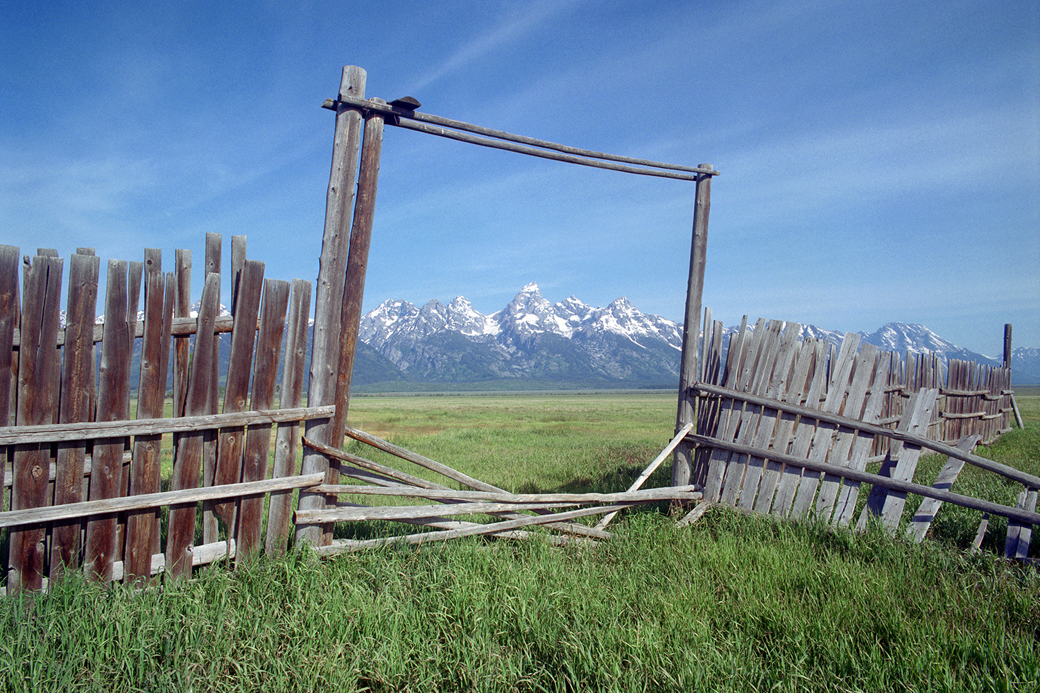
This Black-billed Magpie acts rather important in guarding the gate on the Mormon farm. The spectacular backdrop behind this gate is Grand Teton National Park. What a view! Image # 06857.
If this "one-holer" were mine, I would reverse its orientation, so that I could contemplate the Grand Teton National Park. And enlarge it for room enough for a tripod... Image # 06858.
The Grand Teton National Park gives many residents that "room with a view." This iconic barn is a nostalgic symbol of the rugged life the early Mormon settlers had, trying to make a living in this beautiful place. Image # 06859.
As the late afternoon sun descends behind Mount Moran, the waters of Jackson Lake become calm. This radiant back light is just one of the many moods of Grand Teton National Park. Image # 06860.
This split rail fence in Grand Teton National Park is far more decorative than functional. While it will not restrict wildlife, it sure attracts artists. Image # 06861.
In and near Grand Teton National Park, several herds of bison graze on the ranches just east of the Grand Tetons. As large as the bison are, they are dwarfed by Mount Moran in the hazy distance. Image # 06863.
This is a classic view of the Snake River, as it wanders south through Grand Teton National Park. Mount Moran is on the right in this peaceful image, made in the fleeting color before dawn. Not only are the fall colors performing, but so are the elk which I often hear courting in early morning. Wish you could be in the foreground? Image # 36945.
Enjoy the sound of silence as a new day begins in the Grand Teton National Park. Bathed in pink light at sunrise, Mount Moran presides over this Wyoming dawn, even though it is technically not one of the four Grand Tetons. Image # 36959.
Within Grand Teton National Park, the Grand Tetons preside over two lakes created by their snow runoff. Jenny Lake is well known, and just to its north sits String Lake with this majestic perspective on Grand Teton. Image # 37008.
The power of the Grand Tetons is evident in this memorable image made from the shores of Jackson Lake, one hour after sunset. I love the stunning scenery of Grand Teton National Park, and this image removes all distraction from the strength of these iconic peaks. Image # 37014.
I was hungry when he found this field northwest of Jackson, Wyoming, so he thought these baled haystacks look very much like whole-grain bread loaves, with the world-class Grand Tetons in the background. Now, which way to the Bunnery for a treat? Image # 37065.
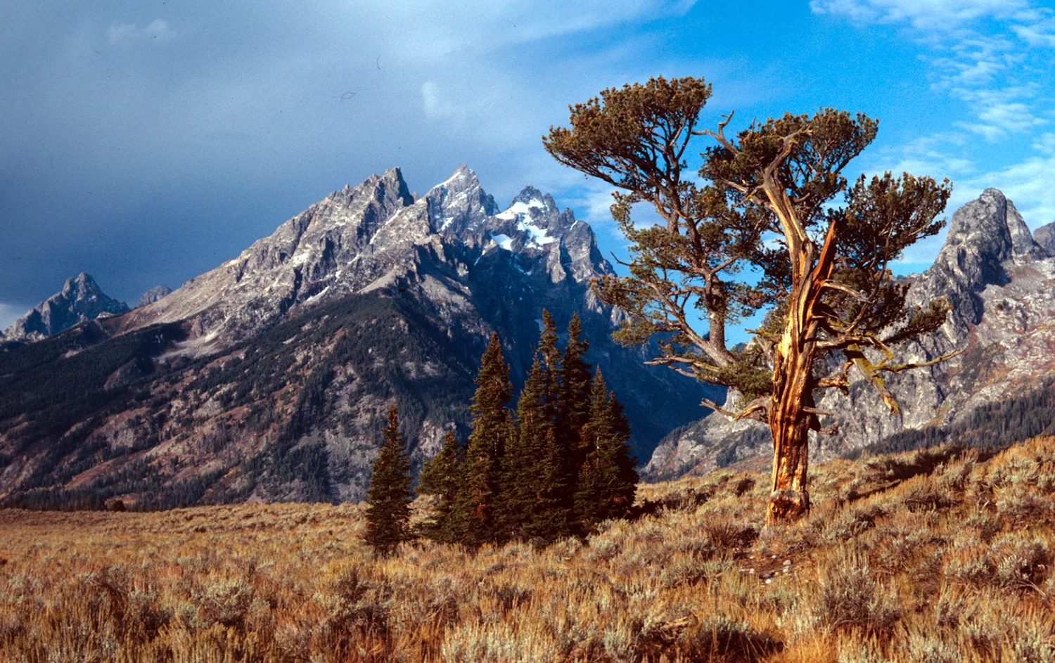
Just below the Grand Tetons, this ancient pine reigns over the surrounding mesa. Native Americans revered this tree, which is one of the oldest in the west. I feel it is perfectly named, and it sure has a magnificent place to call home. Image # 37216.
The motion of water tumbling over rock is mesmerizing, as is the novelty of enjoying so much water closely and vividly. This is located in the Roaring Fork section of Great Smoky Mountains National Park. Image # 04457
This barn in Cades Cove was vital to store harvested crops, as there was no refrigeration. Every board was hewn by hand. Image #08195.
This was the primitive door to the Ephraim Bales Barn, showing the marks from the laborious axe-work to shape every board. Image # 08196.
A century ago, self-sufficiency was the rule in the Cades Cove valley. This mill was important, to enable farmers to grind their corn and wheat into flour. Image # 08206.
This land was acquired in 1820 by the State of Tennessee from the Cherokee Indians. Settlers transformed virgin wooded land into productive farms. This former pasture is very gradually being reclaimed by the forest. Image # 08210.
More than twenty species of plants and trees are coming back to life as spring visits Cades Cove. If you listen, the birds are also returning. How many shades of green can you have in your palette? Image # 08216.
This Park features the finest collection of more than 80 log buildings in America - every one of them built without any power tools. Here is a large barn that was fifty yards from the farm house. Image # 08197.
Ephraim Bales gradually built a fully self-sufficient farm, which was important in the century prior to refrigeration. Corn was harvested and stored in this corn crib to feed animals, and was ground into flour for baking. Image # 08198.
This building was really more of a small barn than a "pen". It was the place where hogs were stored to protect them from bears. Image # 08200.
Ephraim Bales built his hog pen in a location more than 100 yards from his house - both to give him distance from the "pig sounds" as well as from their aroma. Image 08199.
This was a distinctive style of barn built in the southern Appalachian region. Hay was stored in the upper level and livestock on the ground floor. Image # 08205.
This house was large for its time, built entirely by hand, with axes to shape the timbers and shingles. The stone fireplace was located in the center, to allow its heat to radiate to each room in the winter. Image # 08201.
This house reflects the skills and techniques brought into the mountains in the mid-1850s. Privacy in the home was rare. Life centered in the main room. Children were welcomed: the more kids, the lighter the farm work. The home was a business, school, hospital, orphanage, nursing home and poor house. Image # 08202.
The roof over the Ephraim Bales house featured split wood shingles, each shaped by hand. Notched corners on the walls needed no pegs or nails, as gravity locked them in place. Windows and doors were small, to conserve heat and maintain the strength of the building. Image # 08203.
The Primitive Baptist Church began in 1827, and the adjoining cemetery shows names of early settlers. Image # 08215.
The Cherokee described these mountains as shaconage, meaning "blue, like smoke." The eastern band of Cherokee now live on its reservation next to the national park. They are descendants of those not forcibly removed in the 1830s. Image # 08220.
The Roaring Fork area of the Park offers endless cascades running through vibrant moss-covered rocks under a canopy of lush foliage from old-growth forests. Image #08221.
This park has magnificent forests in which we can hike, photograph, and contemplate the timeless appeal of nature. Image # 08218.
The Park is home to 200 species of birds and 60 species of mammals. Wild Turkeys are occasionally seen in the morning, making their rounds. Image # 08217.
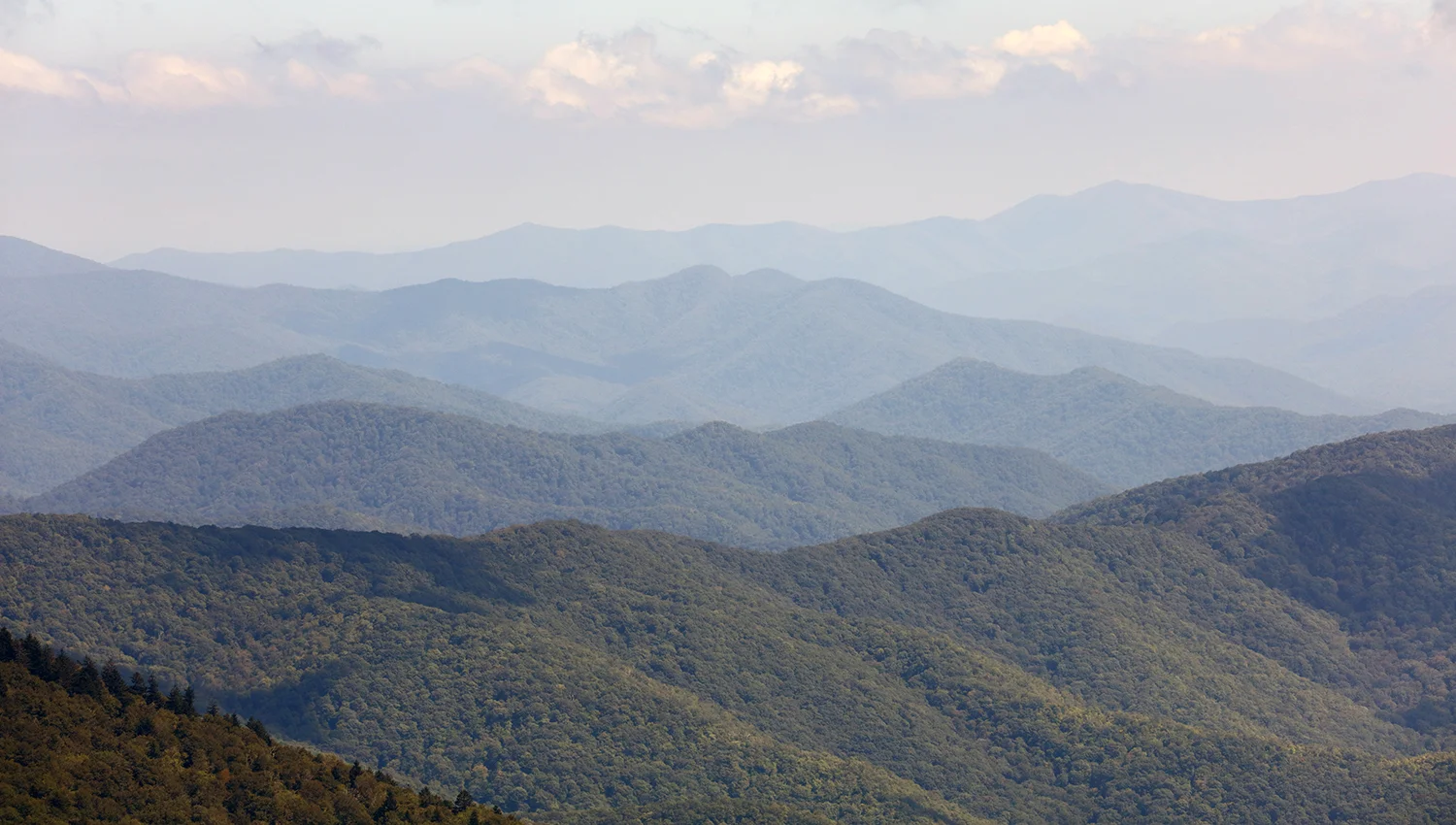
From Clingmans Dome, in several directions, the receding peaks and valleys become increasingly gray and blue. This is the reason the Great Smoky Mountains earned their name. Image #08220.
In the center of Cades Cove, there are several expansive meadows. In early morning, they are often blanketed in mist - yet when the sun burns the mist away, we are left with a lush panorama to enjoy. Image #08213.
Poet Robert Frost would have loved to spend time here, writing about fences and paths and dogwoods and life. Image # 08214.
Think about the times represented in this image. John Oliver was born into a new republic, served in the War of 1812, and died during the Civil War. Plus, he was the first white settler in Cades Cove. Image # 08211.
For more than a century, this was a culture of limited supply and minimum waste. A sense of community filled Cades Cove. With axe, plow and gun, these hardy settlers transformed old forests into a vibrant mountain community. Image # 08207.
Split rail fences were common in Cades Cove, as well as being practical. This would be a great place and time to sit and contemplate the good old days. Image # 08209.
This vista is delightful to watch from dawn to dusk, with changing light and changing surf. Image #08555.
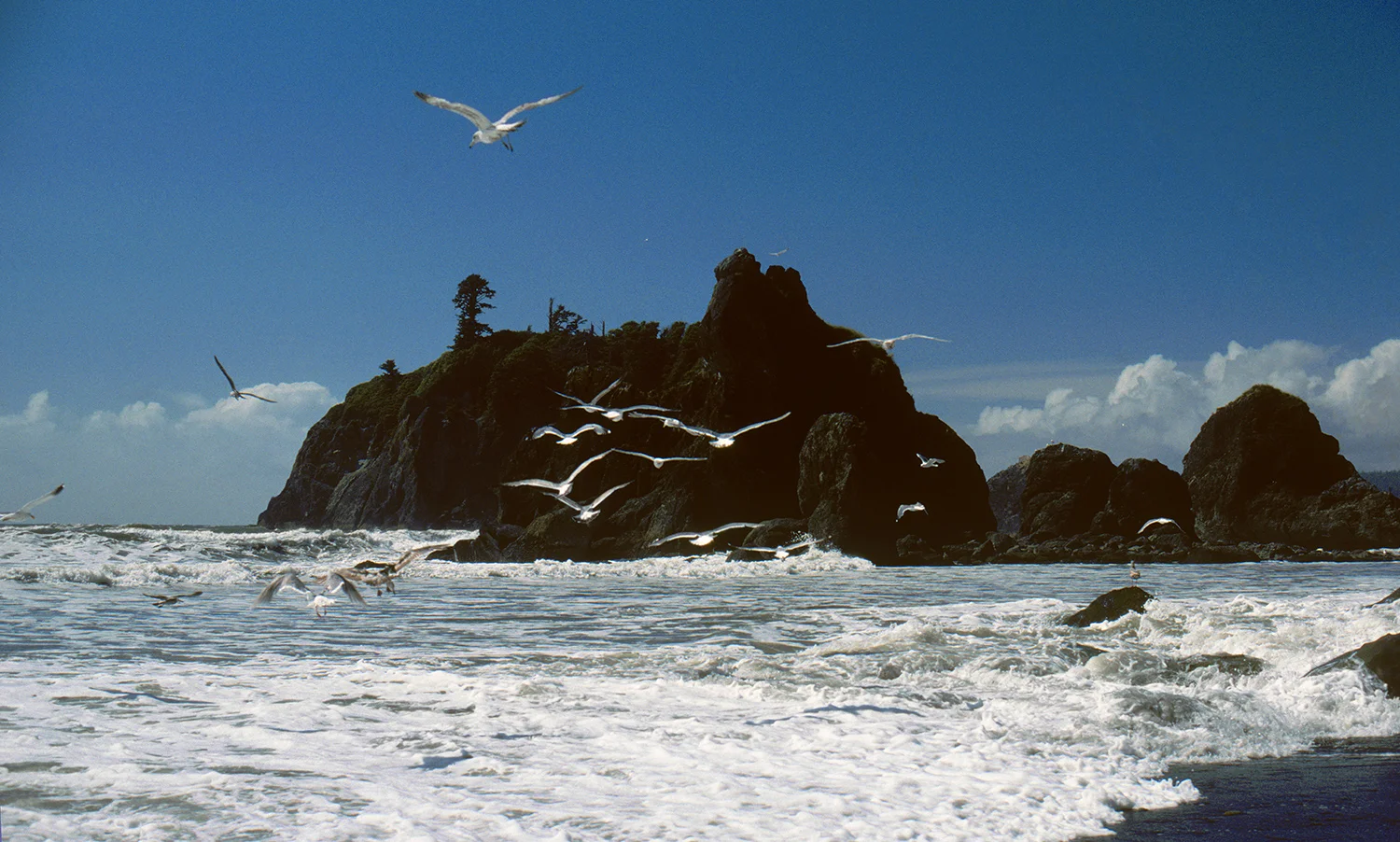
Olympic National Park protects more than 60 miles of wilderness beach and jagged headlands. This rugged shoreline is a popular hangout for seabirds and marine mammals. Image # 06404.
This inlet at Kalaloch beach is surrounded by driftwood that has been pounded into smooth souvenirs from coastal forests. This wilderness oasis is one of the most relaxing places on the Pacific coast. We are often preoccupied with filling space, and Kalaloch is a place where the space fills you. Image # 06411.
Linger near this delightful stream, flowing gently underneath the magnificent old growth forest in the Sol Duc region of Olympic National Park. Do you hear the sound calling to you to leave your stress back at the office? Image # 06421.
The waves never stop. Sometimes violent, but generally mild, and they deliver the rhythm of the Pacific. Image #08557.
Walk in this old-growth forest, which is located about 12 miles west of the glaciers on Mount Olympus! This is a remarkably diverse park. Image # 06430.
Lake Crescent is the largest lake in Olympic National Park. Driving along the shore reveals wonderful views of the mountains on the other side. Image #08552.
The lush forests around the Sol Duc area receive nearly 140" of rainfall each year, as the moisture-laden clouds drift in off the Pacific, and approach the Olympic range of mountains - and dump their water in this rain forest. We are the beneficiaries! Image # 06433.
Just north of Kalaloch sits the beautiful Ruby Beach, with tidal pools and driftwood. A great place to walk. Image #08553.
The rocks in this stream are caressed by water and largely covered by moss. Not a bad life! Image # 06441.
I love this stream (as you realize by the number of images I made in this area). This is near the Sol Duc Hot Springs. Image # 06445.
President Franklin Roosevelt urged Congress to protect this fragile wilderness, and Olympic National Park was created in 1938. As soothing as this image is to the eyes, imagine the gentle sound of this satin water inviting you to sit, take a deep breath, and linger. Image # 06446.
This stream runs near the Sol Duc Hot Springs and the Hoh Rain Forest, two of the unique gems in Olympic National Park. Often the most memorable travel experiences are about being able to forget everything. Image # 06448pan.
Enjoy this old growth forest located in Olympic National Park near Hurricane Ridge. Olympic National Park is perhaps the most diverse national park in America. Imagine the stories these spruce trees could tell. Image # 36891.
Beach logs are the bones of a rain forest picked clean by the sea. Image #08556.
On the road leading up to the summit of Hurricane Ridge, the spruce forest competes with deciduous trees for sunlight - and for our attention. Image # 36911.
Olympic National Park in Washington State is among America's most diverse parks, awakening your senses. Smell the salt air on the Pacific coast at Kalaloch. Feel the water rushing through your toes. Hear the gulls calling you to linger a while. I regard Kalaloch is one of Olympic's most relaxing gems. Image # 36937.
Deep in Washington State's Olympic National Park lie the Sol Duc Hot Springs and the lush Hoh Rain Forest. With 12 feet of annual precipitation, this park easily wins the award as America's wettest park. Hiking down a trail from Sol Duc, I fell in love with this stream. Listen - can you hear it? This place indeed offers a tonic of wildness, and this image is a remarkable antidote to stress. Image # 37210.
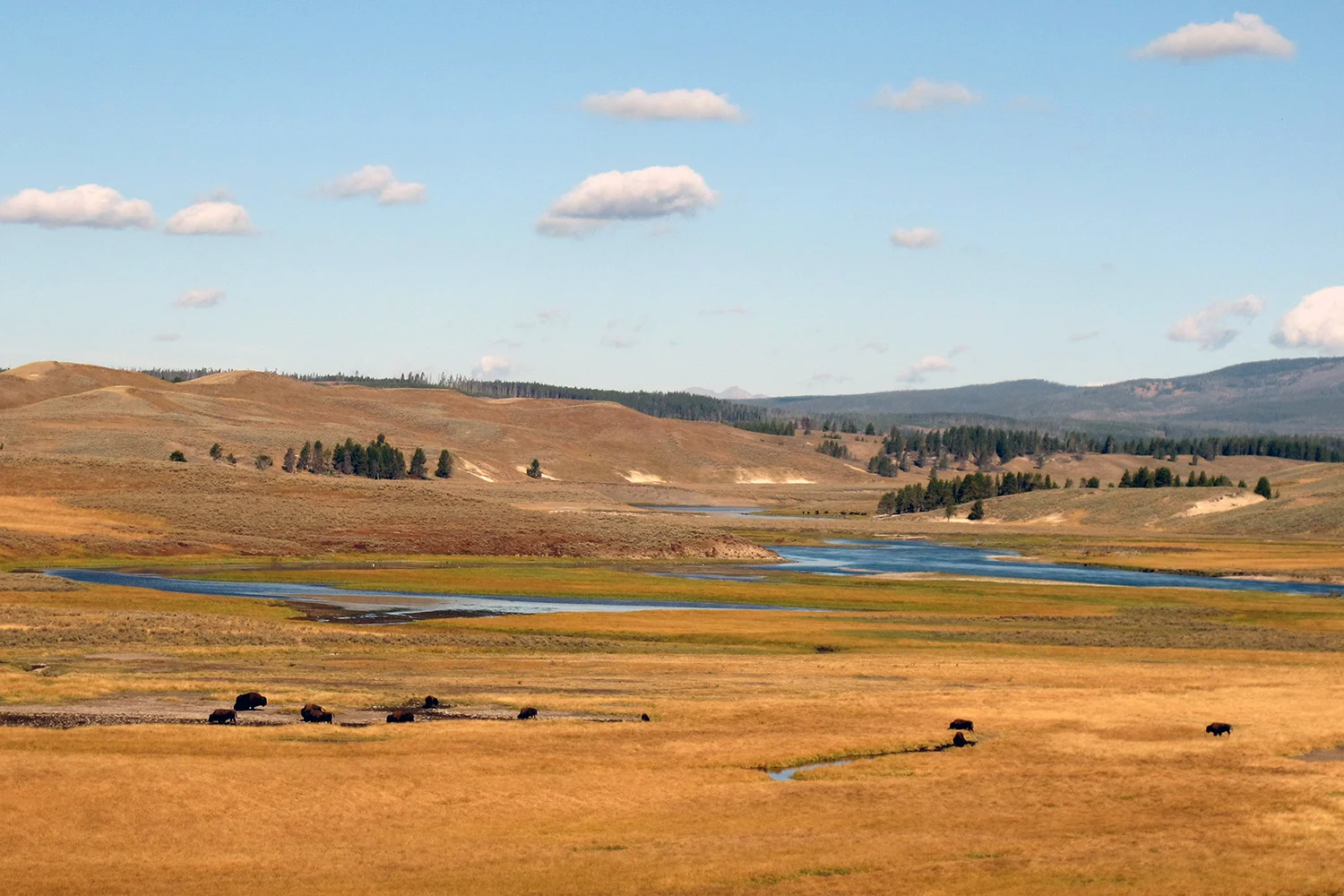
The Hayden Valley was formed 10,000 years ago when melting glacial ice 3,000 feet thick created a lake larger than today's Yellowstone Lake. The tree line around the perimeter marks the ancient shoreline. The valley, 9 miles long and 6 miles wide, is the year-round home for nearly a thousand bison; elk and grizzly bears also frequent the valley. Savor the sense of open space as bison graze near the tranquil Yellowstone River. Image # 06864.
The Yellowstone River eroded a deep chasm known as the Grand Canyon of the Yellowstone. The steep sides of the canyon's walls express the park's complex geologic history with colored sandstone and occasional vegetation offer many treats for the artist's eye. There is also a sense of littleness as we try to comprehend the mighty architecture of nature. Image # 06865.
The expansive Hayden Valley offers visitors lots of wildlife, and miles of open space with no hand of man. The Yellowstone River creates one of the finest examples of the classic "S curve" this artist has ever seen. Travel vicariously with me - so that you measure luxury not in the stars your hotel has earned, but in the absence of footprints through the lands you visit. Image # 06866.
The graceful hills on the eastern shore of Yellowstone Lake are softened by smoke from several fires. Fires are common in Yellowstone, often launched by lightning. Memories made in Yellowstone will last infinitely longer than you think. Image # 06867.
In the Lamar Valley, this colorful stand of Cottonwood trees are at peak color in late September, even though the bison nearby are unimpressed. The howl of wolves can often be heard in this remote valley, and they can sometimes be seen hunting. Image # 06868.
Hydro-thermal features are fragile rarities of nature, with water that traces its source back to an underground world. Yellowstone preserves the largest collection of hydro-thermal features on the planet. The many diverse limestone formations around Mammoth Hot Springs are fascinating to observe. Image # 06869.
This hydro-thermal feature in Yellowstone's Mammoth Hot Springs area offers remarkable variety to the eye. A network of fractures and fissures form the remarkable plumbing system that allows boiling water from underground to reach the surface. This is definitely a "look but don't touch" zone! Image # 06870.
Yellowstone National Park has the world's largest collection of geysers. Old Faithful is in the Upper Geyser Basin, one of three large geyser basins along the Firehole River. Fueled by the volcano 3-5 miles underground that is still active, many of the hydro-thermal features are filled with boiling water. This iconic geyser erupts on a fairly regular interval (about every 70 minutes), and attracts crowds of visitors to watch each performance. Image # 06871.
Yellowstone is a diverse and mysterious land which inspired early explorers to persuade the U.S. Government to create the world's first national park. More than 10,000 thermal features are located in the park, more than anyplace else on earth. This paint pot is very hot, very colorful, very mysterious. Image # 06872.
Boiling water sure can be colorful. This is one of the deepest geothermal features in Yellowstone, in the West Thumb area 100 yards from Yellowstone Lake. Image # 06873.
Immerse yourself in the diverse wonders of Yellowstone National Park. This was America's very first National Park, an idea that has spread worldwide. Bison roam freely all over Yellowstone, and here provide a welcome foreground to Yellowstone Lake as they wander across the "front yard" of the Lake Village Lodge. Image # 06874.
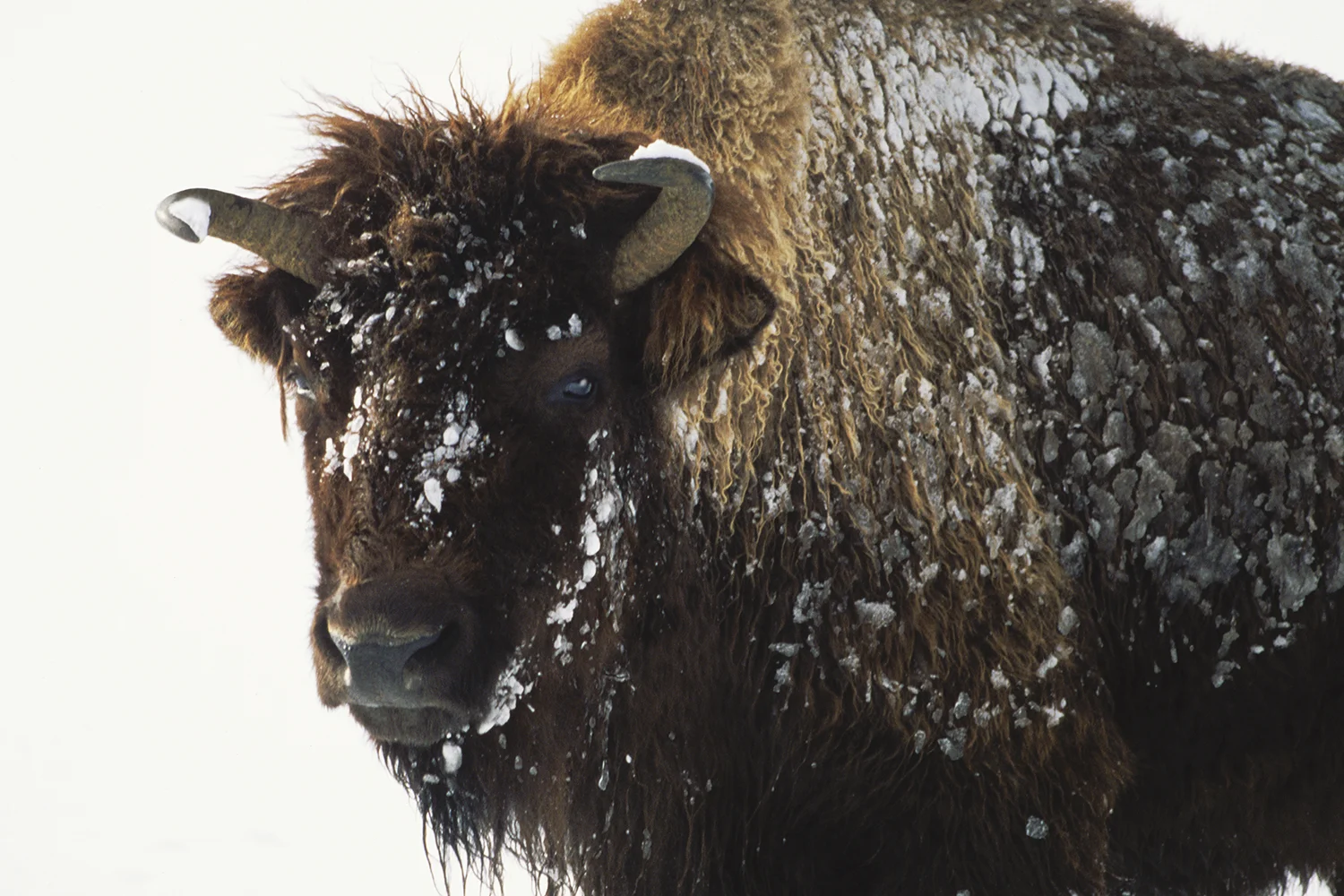
This giant bison met me near the Madison River in Yellowstone National Park. I had been stationed 200 yards away with my tripod and camera, and watched him slowly move toward me. Not sure whether my good looks or his curiosity motivated his approach. Despite the 20-below temperature, his powerful presence gave me all the adrenalin I needed to make this photograph and then move on! Image # 37178.
The regal Mute Swan is a large bird, often 25 pounds as an adult. They are not native to North America, but have adapted well to various ecosystems in the United States. They are voracious eaters of submerged aquatic vegetation and generally live as one of a pair for life. This swan honored me as it passed slowly by in Yellowstone's Madison River. Image # 37180.
When frost visits leaves during cold nights, it often enhances their look. These were photographed near the Madison River in Yellowstone National Park at 10-below zero. Image # 37186.
In the northern part of Yellowstone National Park lies this dramatic chasm with a dazzling palette of reds and yellows. While it is much smaller than the "real" Grand Canyon, it stretches 20 miles and projects rugged beauty in the strata that reveal its formative process. Image # 37311.
"El Cap", as El Capitan is affectionately known by lovers of Yosemite National Park in California, is the giant rock face on the north side of the valley, visible from many vantage points. It is a very challenging technical rock climb. I enhanced this view by including the tranquil Merced River. Image # 01932.
This iconic cliff in Yosemite National Park is respected around the rock climbing world. It is hard to imagine how serious climbers scale the sheer face of this monolith, but they do - and even secure a hammock to sleep half way up. I prefer to simply watch. Image # 01937.
The Mariposa Sequoia grove in Yosemite National Park is very impressive, and is where John Muir took President Theodore Roosevelt camping on his visit to the park a century ago. Many of these giant trees have individual names. Image # 01946.
This is the most popular vantage point to view the remarkable Yosemite valley, in the eastern edge of California. El Capitan presides on the left, and Half Dome in the center teases you to enter the valley and stay. I believe this point is very well-named. Image # 01957.
Enjoy nature's skyscrapers that are older than King Tut. These giant sequoias are 27 stories high and seem even more majestic when they tower over a snow-covered forest floor. I love this Mariposa Grove of Giant Trees located in southern Yosemite National Park. Image # 05664.
Life is not measured by how many breaths you take, but by how many moments take your breath away . . . El Capitan is an iconic visual treat in Yosemite National Park. Here is "El Cap" in the afternoon light, with its reflection in the gentle flow of the Merced River. Visit this spot in early morning, and you will have it all to yourself. Image # 07613.
Most park visitors arrive at Yosemite from Route 41, pass through the tunnel - and see this spectacular vista! It is an indelible first impression of the valley and the view changes with the seasons and with changing light. John Muir regarded the awesome natural beauty of Yosemite Valley as a sacred place with restorative power. Linger, and thank President Theodore Roosevelt for protecting this special place. Image # 07614.
The giant sequoias in the Mariposa Grove are quietly spectacular. They are not the tallest in the world, nor are they the oldest, but their longevity and size are very impressive. A walk through this grove of gentle giants will linger in your memory. Image # 07615.
There are mule deer who call the Mariposa Grove their home. Human visitors are frequent enough that the deer are comfortable in close proximity. Quite a counterpoint between the delicate deer and the mighty giants. John Muir wrote that his beloved Yosemite “was the the grandest of all the special temples of Nature that I was permitted to enter.” Image # 07616.
Half Dome is the single most famous granite feature in Yosemite National Park. It can be enjoyed from the valley floor, and even more from the Glacier Point shown here. As the sun shifts slowly to afterglow, the majesty of this peak (along with its neighbors) becomes compelling to watch and enjoy. Image # 07617.
As often as Yosemite has been photographed and written about, no one has come close to naturalist John Muir in expressing the sheer joy of the place. The California Black Oaks were performing in the El Cap Meadow, showing off their color as if to persuade fall to last another few days before the inevitable shift to winter. Image # 07620.
When the moon is full, it illuminates the valley more than you might imagine. Yosemite combines the evidence of ancient geological forces with the play of waterfalls and inspiring icons like Half Dome and El Capitan. Image # 07621.
What a treat to enjoy the California Black Oaks turn from ordinary to spectacular. This is one of the colorful treats that Yosemite promises to you in the fall. Image # 08022.
hill98-002.tif
Skier-in-recovery Wayne Hill knows that Colorado offers wonderful skiing, yet is even more enjoyable to explore in the summer. This vista of the San Juan Range of mountains awaits you as you begin your adventure on Million Dollar Road north of Telluride. These horses have no idea how lucky they are to call this setting home. Unspoiled and magnificent, between Ouray and Telluride, it is well worth the drive to be there! Image # 01313.
Much of the experience of Zion National Park is gained by hiking. Trails go in every direction, and this one along the Virgin River leads to spectacular cliffs. Image # 08276.
Do you need stress relief? Slow down beside the rhodos and the old millpond at the Mabry Mill, located at milepost 181 on the Blue Ridge Parkway in southwest Virginia. This picturesque mill began operating in 1908. The National Park Service lists the Parkway as the most visited site in the National Park system. Yet this image offers a wonderful sense of calm and a healthy dose of nostalgia. I can also recommend the pancakes in the restaurant 100 yards behind my tripod... Image # 02221.
Denali National Park is one of North America's natural treasures, crowned by Mount McKinley, the highest peak on the continent at 20,320 feet. This vast park is far larger than Massachusetts. To protect its fragile ecology, there is only one 91-mile road (mostly unpaved) which ends near the center of the park. The mountain is referred to among Alaskans by its Athabascan Indian name Denali "the great one". It is 20 miles away from its remarkable reflection in Wonder Lake. I was very lucky to make this image in the summer, when "The Mountain" is rarely clear. Image # 05232.
This large-format image conveys the power of the Potomac River as it descends through Great Falls at dawn. Many people consider these Great Falls to be the most spectacular natural landmark in the Capital Region. Here, the Potomac builds up speed and force as it cascades down several 20-foot waterfalls before it flows through the narrow Mather Gorge. Image # 02283.
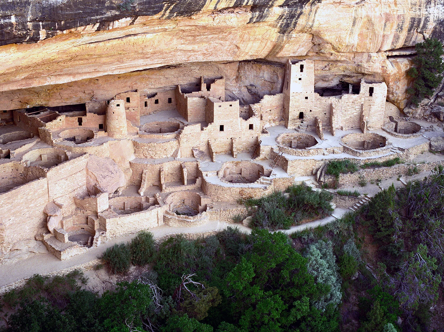
Where did they go? Visitors to the Cliff Palace in Colorado's Mesa Verde National Park have many questions about the Anasazi ruins that have been discovered and protected. The cliff dwellings here are but a fraction of what this vanished culture built and then deserted 800 years ago. Lingering in this special place, you can feel the presence of the Anasazi people still, ancestors of the Pueblo Indians, that lived here until about A.D.1200. How did they live in America's first high rise? Image # 01246.
Take a picnic, take a blanket, take good friends, and head to America's only National Park for the Performing Arts. A great way to spend an evening! My mosaic of people prior to the performance is fun to study - you may even be in it! Image # 02888.
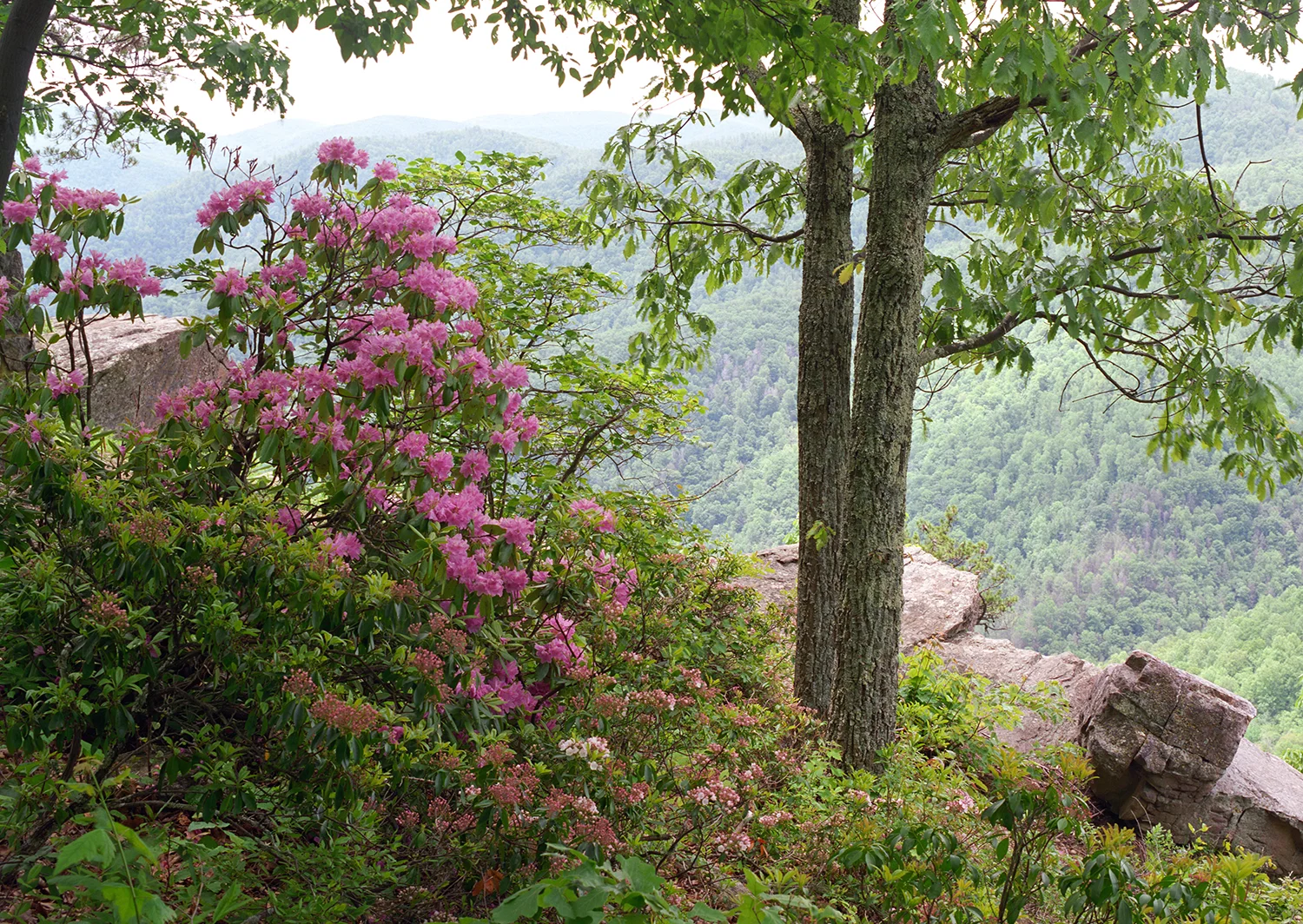
Driving or hiking along the Blue Ridge in late spring will connect you with wonderful rhododendren in bloom. Here is evidence that late spring is a great time to be in the Blue Ridge mountains. Image # 02269.
Late September brings a palette of brilliant colors. This early performance was on the shore of the upper Hudson River. Image # 05491.
Who would guess there are huge sand dunes in the middle of Colorado? The main dune field covers 30 square miles, with individual mounds standing 650 feet high. Sculpted by wind and water, how did they get there? Enjoy the patterns of sun and shadow as you labor to reach the top. It took me over an hour to hike from this spot to the "summit". These dunes are one of the most unique places in the American west. Great Sand Dunes National Park is one of the newest national parks, re-designated in 2004. Image # 05526.
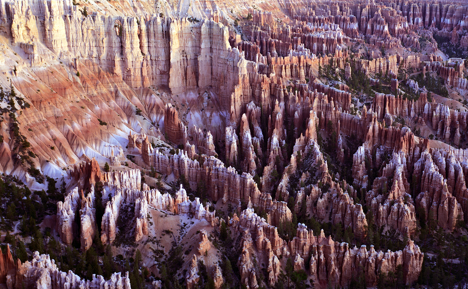
When you travel to visit Bryce Canyon National Park, you will drive across many miles of ordinary Utah terrain - then the Wow! factor hits you as you first gaze down on Bryce Canyon. It is a unique and memorable geologic marvel, featuring a dazzling palette of oranges, yellow and beige sandstone. I love to hike the rim and then plunge down into the Hoodoos ("fairy chimneys") as the vertical formations are called. Image # 05624.
The Virgin River runs down the valley in magnificent Zion National Park, and is a fitting companion in this image with the iconic Watchman. Image # 05678.
The gentle backlit Cottonwood trees provide contrast with the strong walls of the canyon in Zion National Park. There can be great rewards for stepping off the beaten path. It is surely true in Zion: what fills your eye will fill your heart. Image # 05691.
These unique Hoodoos are the signature feature of Bryce National Park. Image # 05695.
The signature Hoodoos (also known as "fairy chimneys") in Bryce National Park are fascinating when backlit by early morning light. Image # 05697.
Seeing Bryce Canyon from the rim is a memorable experience. Even better - head down a trail into the amphitheater and onto the canyon floor to be among the delicate "Hoodoos", these magical multi-colored formations. This is a unique place in all the Americas. Image # 05703.
Mount Rainier is seen here from Reflection Lake in Mount Rainier National Park, WA. This volcanic mountain is much larger in person than it appears in photographs. Image # 06753.
At first light, leave the Paradise Lodge in Mount Rainier National Park, drive east and arrive at this lake with a misty view of Mount Rainier. It does look like paradise. Breakfast can wait. Image # 06755.
Enjoy the sound of silence as you wander among rhodos in bloom under 27-story skyscrapers that are as old as King Tut. This special grove is located in the northern section of Redwood National Park, north of Crescent City, California. Image # 06803.
Along the shores of New York's Elk Lake, near North Hudson, a 12,000-acre private forest preserve is nestled in the heart of the High Peaks. This was described by the National Geographic as "the jewel of the Adirondacks". Enjoy the solitude of this tranquil wilderness resort. Image # 06837.
Alaska is so vast that if anybody could figure out a way to steal Italy, Alaska would be the place to hide it. In this image, the sounds of nature are amplified on the shores of Wonder Lake, deep in Denali National Park. This feels like it is a million miles from civilization, which is just fine. Image # 06907.
You've seen pictures of these sculpted presidents for years, but until you stand beneath them you do not appreciate their scale and their power. Sculptor Gutzon Borglum led a team of workers on narrow cables to create these patriotic faces. If their entire bodies were carved in the same scale, they would have been as tall as a 40-story building. Image # 07004.
George Washington's powerful profile is perfectly placed when viewed by early morning light. This icon on Mount Rushmore in South Dakota was sculpted by Gutzon Borglum over a number of years starting in 1927. His head is 60 feet tall, his nose is 20 feet tall, with an 18 foot wide mouth. Each eye is 11 feet across. Image # 07006.
The elegant Anhinga is a water bird. It dives and searches for prey underwater, then has to sit and dry out its wings and feathers to warm up, as it does not have protective oil coating its skin like ducks and geese. Image # 07253.
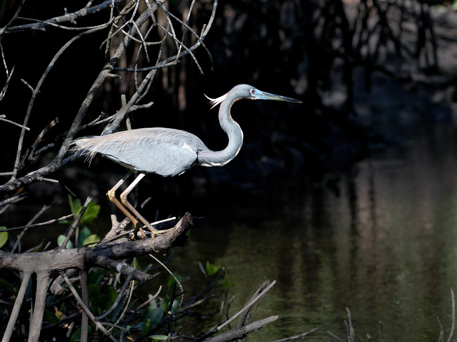
The Great Blue Heron, seen here in a mangrove tunnel in the Everglades National Park, looks like two very different birds. It is often seen in shallow wetlands, motionless with its long neck leaning forward, trying to convince a fish that it is just part of a tree. When in flight, its neck compresses into an S curve and it is graceful in flight. Image # 07251.
To truly experience Everglades National Park, you need to be on the water. The artist loved the view of this Snowy Egret as he glided through a mangrove tunnel. Image # 07252.
For 15 miles along the shore of Lake Michigan, Indiana Dunes National Lakeshore Park has much to offer, with 45 miles of trails and rugged dunes and interesting wildlife. Image # 07408.
Indiana Dunes National Lakeshore is located on the shore of Lake Michigan at the very top center of Indiana. Image # 07409.
In Rock Creek Park in Washington, D.C., there are a dozen bridges that cross the Rock Creek, and the Boulder Bridge is among the oldest. It was built in 1902 at a cost of only $17,600. It is beautiful and was added to the National Register of Historic Places. Image # 07591.
Rock Creek Park is truly a gem in our Nation's Capital. It offers visitors an opportunity to reflect and soothe their spirits through the beauty of nature. Fresh air, majestic trees, wild animals, the ebb and flow of the Rock Creek, and thousands of years of human history are collectively working so we can enjoy the delicate aura of the forest in the midst of a vibrant city. Image # 07592.
The dogwood is among the earliest harbingers of spring in the Blue Ridge of Virginia. After a long winter, it is a most welcome sight - you know a wonderful spring season is not far behind. Image # 35166.
This old-growth forest is near the Blue Ridge Parkway in central Virginia. Throughout the Skyline Drive and the Blue Ridge Parkway, there are wonderful trails waiting for you to discover. Take one, hike 100 yards or more, and enjoy the sounds of nature and the comforting absence of the hand of man. Image # 35907.
This is one of the most memorable of the state parks along the Oregon coast. When I arrived at Sunset Bay State Park, I asked the ranger if there would be a sunset. As I camped here, I got my answer and enjoyed the performance. Image # 36594
Crater Lake National Park in central Oregon offers lots of hiking around the rim, and the trail nearly always offers stunning views of this magnificent lake. The water color is deep blue, surrounded by sheer cliffs. It is the deepest lake in the United States, and the park was created in 1902 to protect these unique natural resources. Image # 38104.
This is one of countless possibilities, offering wonderful textures and colors in White Sands National Monument near Almagorda, NM. Image # 04151.
Wonder Lake changes its moods hourly, as the sun and clouds play with the landscape. Here is the point in brilliant sunlight while The Mountain is shrouded in clouds. Image # 06908.
The sculptures at Mt. Rushmore are impressive by day, and even more dramatic by night. Powerful. Image # 07005.
This remarkable ruin is in Mesa Verde National Park, in southwestern Colorado. This remarkable place generates almost as many questions as answers. Image # 05634.
A Saguaro cactus begins its life as a shiny black seed no bigger than a pinhead. Yet it can live nearly 200 years, and can grow to nearly 50 feet tall! Image # 089190.
This giant cactus plant rewards patient visitors to the Saguaro National Park with delicate blossoms in the spring, that only appear on the very tops of each of the columns and arms. Well worth the wait and the search. Image # 08191.
Arriving by seaplane from Key West 70 miles away, this National Park looks tiny. It also encompasses nearly 100 acres of protected water around the fort. Discovered in 1513 by Ponce de Leon and named after the turtles on the small island. Image # 08248.
Fort Jefferson was constructed in the 1850's and is the largest brick masonry structure in the Western Hemisphere, with more than 16 million bricks. The lighthouse was built in 1856. Image # 08250.
Built in the 1850s, the six-sided fort had 420 heavy guns, as defense near one of the world's busiest shipping lanes. Image # 08249.
This fort in Dry Tortugas National Park was used as a prison during and after the Civil War, and its most famous prisoner was Dr. Samuel Mudd, who treated the broken leg of Lincoln assassin John Wilkes Booth. Image # 08246.
Fort Jefferson was built in the 1850s to protect one of the most strategic deepwater anchorages in North America, and was an important advance post for ships patrolling the Gulf of Mexico. Image # 08247.
More than 16 million bricks were used to build Fort Jefferson in the 1850s - and the fort was never completed due to the outbreak of the Civil War. The park is known for abundant sea life, tropical bird breeding ground, colorful coral reefs, and legend of shipwrecks and sunken treasures. Image # 08245.
This nautical National Park is known for abundant sea life, tropical bird breeding ground, colorful coral reefs, and legend of shipwrecks and sunken treasures. Image # 08269.
Dry Tortugas National Park is known for abundant sea life, tropical bird breeding ground, colorful coral reefs, and legend of shipwrecks and sunken treasures. Image # 08270.
This large-format panoramic image conveys the power of the Potomac River as it descends through the Great Falls in early morning. Many people consider these falls to be the most spectacular natural landmark in the Capital Region. Here, the Potomac builds up speed and force as it cascades down several 20-foot waterfalls before it flows through the narrow Mather Gorge. Image # 02283.
This delightful lake is the reward for a two-hour hike north of Estes Park, in Colorado's rugged Rocky Mountain National Park. This is a wonderful place to mend your soul in pampering tranquility. I sure appreciated the treat after the uphill climb to reach this spot, as It indeed is a gem! Image # 01528.